Covid Cross Day #8 Noblestown, PA to Barkcamp State Park, OH
Covid Cross Day #8
June 8, 2020
Noblestown, PA to Barkcamp State Park, OH 87 Miles
8:02 AM Finish 6:27 PM
Ride Time 8:12:30
Ascent 3495 Feet
Descent 3241 Feet
Tour Total 655.6 Miles
I had a good nights sleep stealth camping a hundred feet off the Panhandle Trail. I drank quite a few pints last evening at the Helicon Brewery yet managed to safely pedal down the trail to find a good spot. I could hear distant cars from Highway 22 all night long. The crows started cawing at 6 AM yet I was able to get a few more winks. In the morning, I took the tour's first poop in the woods. I had noticed Jewelweed growing around my campsite, which was a cause of concern because Jewelweed grows alongside poison ivy. I didn't see any poison ivy however. I was all ready to go by 8am. It was a bright sunny day.
There were various parking areas with picnic tables and out-houses at different locations along the trail. At one of the parking lots I noticed a quadriplegic man in a wheelchair who was assembling a recumbent tricycle with hand cranks. It was very cool, and I wished him a good morning. I later saw him screaming down the trail. Good for him! There were runners, dog walkers, and cyclists out enjoying the trail. A pair of day cyclists passed me as the the surface turned to asphalt.
The trail went through the small town of McDonald where there had once been a train depot. I stopped at the Giant Eagle supermarket and purchased two Dunkin Donuts iced coffee‘s and some mini donuts. While I was at the check out register, I smelled the bakery and asked if they had egg sandwiches. I snatched the very last one. There was a massive bridge construction project going on with huge cranes overhead. I stopped to take a photo and the tricycle guy wizzed past me along with several day cyclists. I stopped at a bench to eat my breakfast and upload photos for yesterday‘s post. At mile marker 588 the asphalt ended and I was back on gravel.
I came to a Trail Closed sign, and there was a detour indicated with hand-painted signs. I followed the detour for a couple miles and was uncomfortable being off route. At a certain point I realized that I had missed a turn a long way back, so I turned around and backtracked. I passed the two day cyclists who were now sitting at a picnic table. They shouted, "You’re going the wrong way." I replied that I had I missed a turn. I could see from my elevation profile that the route would have me going over a large steep hill. I rode back while looking for an overpass to cross over Harmon Creek, which I had been following yet was on the wrong side. I finally spotted a bridge above me, but there was no connection to the trail. I had to bushwhack up a steep embankment through waste deep weeds. It was ridiculous but I finally got back on route. It was disappointing to be back in traffic. I had burrs stuck to my socks and weeds wrapped around my front wheel hub. And of course I was now headed up the big steep hill. I almost missed a hairpin turn off. The route obviously wanted to remind me that I was still in hill country.
A little dog chased me down one of the hills. I never got a good look at him, though I heard him barking and his owner shouting "Sadie!, Sadie!". I think I spotted a weasel bounding through the grass. It's tail was way too long to be a squirrel. World Quality Roofing seemed to have a monopoly going in Follansbee. I saw their signs in everyone's front yard, and everyone seems to either have a new roof or their roof had been recently inspected.
The Ohio River came into view and I realized that I was in West Virginia. I had entered West Virginia in Colliers and never passed a border sign. I regretted not getting the opportunity to gather my thoughts and give a proper goodbye to Pennsylvania. We were together for many days. I entered the state on the tour's second day and left on my eighth. It was a good long crossing with lots of hills, some rain and sun, good beer and nice people. Pennsylvania toughened me up and prepared me for the rest of the tour, and I would miss it.
From the top of the ridge I could see distant plumes of white smoke and/or steam from a far away power plant. I pedaled south along the east bank of the Ohio River towards Wheeling. I passed numerous shuttered steel mills along the river. I was on four-lane Highway 2 and there was lots of traffic. It was an industrial area and I longed to get back on a bike path.
I finally figured out how to get on the Wheeling Heritage Trail. Not long after that, I came to a Trail Closed sign and Danger! No Trespassing! I needed to stay on my route so I kept going. I came to a major construction site and had to walk my bike up a steep dirt hill surrounded by active massive construction equipment. I found myself back on Highway 2 which was down to one lane of traffic with pilot cars. I snuck into the middle of the construction one-way pilot car traffic situation. I eventually reached the 'End of Road Work' sign and could once again see the trail below me. I didn’t want to bushwhack down the hill through tall weeds so I kept pedaling and rejoined the trail at Beech Bottom. What an ordeal.
I finally spotted the enormous coal-fired power plants whose giant plumes of white smoke and steam I had been seeing for miles. There was a mammoth water cooling tower. I'd seen many bunnies today. I passed Pike Island locks and Dam, operated by the US Army Corps of Engineers. Riding into Wheeling I spotted a beaver scurrying into some trees growing along the river.
The historic Wheeling Suspension Bridge across the Ohio River had been closed to motorists for some time, and I had been concerned whether or not I'd be able to cross it. Fortunately it was open to pedestrian and bicycle traffic. From 1849 to 1866 it was the longest suspension bridge in the world. In comparison to the Williamsburg Bridge, I couldn't believe how skinny the main cables were. On Wheeling Island I located a Marathon station, where I purchased a Red Gatorade and honey roasted cashews. I talked with locals out front, who couldn't believe what I was doing.
I crossed over the river's western channel and into Ohio, and there was no border sign. Ohio was the tour's fifth state. I found myself on divided four-lane highway 7 which felt like an interstate. I stayed on the horrible highway too long. The exits in Bellaire were confusing. It was hot and I stopped at Subway, where I ordered a tuna fish on a foot-long. Some of the staff was wearing masks and others were wearing gloves. A few were wearing masks with their noses exposed.
I rode out of town on two lane Highway 149. The siena colored streams around here indicated a high iron content. There was not a single cloud in the sky, and the sun was bright. I spotted a stars and bars at mile marker 630. I was again met with Road Closed signs at mile marker 635. I didn't know what to do so I kept on going. Once again there was active massive construction equipment. They were re-doing the cut and I was able to walk around. It was a good thing that I could proceed because it would have been a long hilly detour.
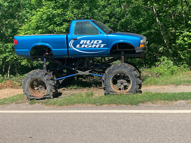
I was chased by two large dogs, and fortunately I was traveling at a good clip. I sped up and lost them. Had they noticed me any sooner there might have been a problem. I passed a large cage of hunting dogs and decided that it would be a good idea to keep my pepper spray in my back pocket. I stopped to take a picture of a jacked-up pick up truck and a guy asked me how far I had pedaled. I told him that I had ridden from New York City, and he asked me if I was normal. I replied, "No. Not at all." The guy seemed like he was drunk or on drugs, or both.
Eastern Ohio welcomed me with steep hills and hot June sun. I lost the shifting capability on my front derailleur. I wasn't quite sure what the problem was, and didn't want to stop. I just wanted to get to my destination and fix it there. I was stuck in my small front chain ring which was fine for climbing all of these steep hills. I’d also been having issues with my right pedal clip. I had some repair work to do in camp.
I rode through Belmont and then had to double back around to get to Barkcamp State Park, which was my destination. I rode up to a gas station at I-70 to buy beer, ice, and pretzels for the campsite. The campground was open, but I had to register and pay for my site online. I chose site number 72. There were no campsite maps posted in the campground and site took forever to find. I essentially made a big circle and was practically all the way back near highway 149, before where I had entered Belmont.
I dried out my tent in the evening sun and fixed my shoe clips and repaired my front derailleur. There was electricity at my site so I ran a line into my tent. I showered and washed my clothing before sitting at the picnic table to edit yesterday's blog post and admire the amazing stars.


Just caught up on reading your post. You're an animal man...your 4th long tour since our 2018 TransAm. I'm sitting here bummed that I've had to cancel my Great Divide ride this year...had Covid not happened I would have been flying to Fairbanks next weekend to start from there. I'm thinking about doing the Southern Tier starting in September. Hope you have a great tour and I'll be following along on your blog. When you get to KY if you decide to dip a little further south to Lexington, you're welcome to stay with us...we have plenty of room.
ReplyDeleteSteve