Covid Cross Day #39 Ovando, MT to Missoula, MT
Covid Cross Day #39
July 12, 2020
Ovando, MT to Missoula, MT 56 Miles
Start 7:12 AM Finish 12:45 PM
Ride Time 5:05
Ascent 578 Feet
Descent 1492 Feet
Tour Total 3250 Miles
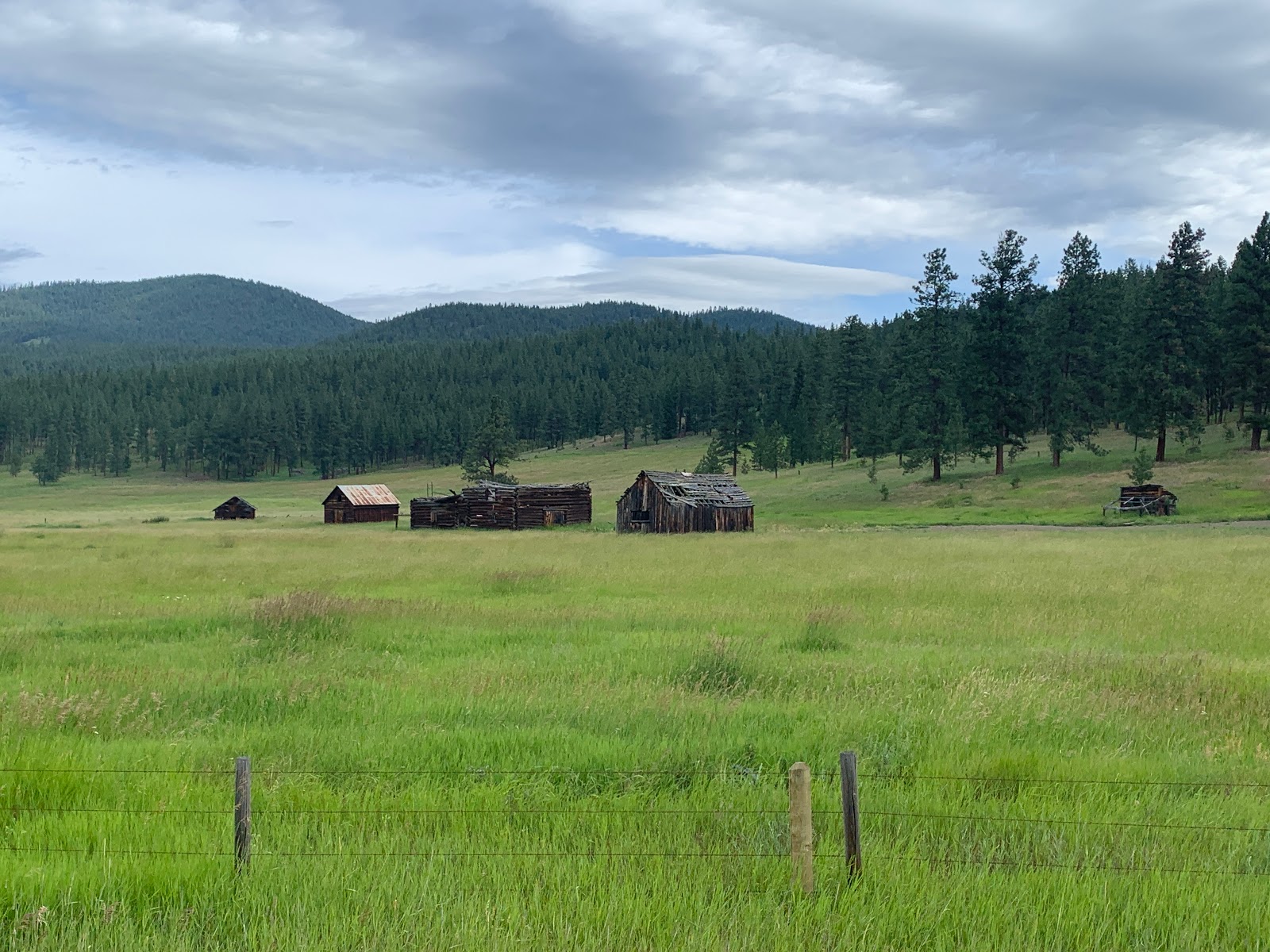
I slept great last night in an actual teepee in the center of Ovando. Inside there were two cots and a tree stump night stand. I inflated my pillow and unstuffed my sleeping bag and silk liner. It got cold during the night and I had to zip up my sleeping bag. There were no bugs and I slept great! On the night stand was a sign-in book and information about the area. The teepee and an old shepherd's wagon stood in a small gravel area in the center of town. An information plaque gave an account of Meriwether Lewis's return through here on the Nez Perce Buffalo Road. I spotted more of the same painted rocks that I'd seen yesterday where I had taken a break before the pass. The morning was still chilly and I put on my sweater. Nothing in the small town was open so I proceeded down the road towards Missoula.
I was riding through the wide Blackfoot River Valley, which was filled with grass, horses, and cattle. Massive ridges towered around me and I could see snow capped mountains to the south. A flock of geese flew in formation above the highway, and I was awed by how they drafted one another. I crossed Monture Creek and noticed anglers getting ready to fly fish. I saw a giant black eagle in flight and was amused by two small white birds pestering and flying right behind it. I had noticed this phenomenon before.
I crossed the Missoula County line, which would be my last county in Montana. The road cut close up against the Blackfoot River which had grown considerably wider since yesterday. I passed a flashing sign that said, "Boat Check Ahead. All Boat Types. Includes Kayaks and Canoes". I could see a weight station and rest area a half mile in the distance. It seemed like there was also a gas station. This was the junction with State Highway 83, which led north to Kalispell and Glacier National Park. The Sinclair station had a mandatory face mask policy, which was in effect throughout Missoula County. Breakfast options were slim, and I purchased a Starbucks Frappuccino, an orange juice, two containers of Cheerios, a Nesquik Chocolate milk, two cheese sticks, and pepperoni snack stick.
Back out on the road I crossed over the brown tinted Clearwater River. I saw firewood advertised for four dollars an armload. It was 9 AM and I already had a headwind. This was supposed to have been an easy day. I crossed the Blackfoot River, which at this point was a hundred feet wide. I was now on the south side of it. The river wound itself around the north side of 5630 foot Morrison Peak, and Highway 200 circled around to the south. I passed Sunset Hill Road as my body began to heat up from the climb.
There were tall straight evergreen trees on both sides of the road. I passed the Lubrecht Experimental Forest, which was part of the University of Montana Forestry Program. I noticed a sign for the Garnet ghost town. I love old ghost towns and doubt that any could surpass Bannack, MT, where I visited two years ago on the Trans Am. It was a chilly descent coming down around the west side of the hill. The sky was overcast with long bands of wispy clouds, and I didn't have cell phone service for much of the ride.
At the intersection of Potomac Road I passed Cully's Bar & Grill, which doubled as a Sinclair station. I didn't stop. I got a text from my mom‘s friend Jill in Cincinnati, whom had received my postcard. Today was Sunday and I used to always talk to my mom on Sundays at 1 PM EDT. I missed my mom. I was still seeing red-tip blackbirds, but as predicted I'd seen no more more sandpipers. Immediately after Johnsrud Park Road, I crossed over again to the north side of the Blackfoot River. I now found myself in a canyon with steep rocky walls. The river was now directly to my left and I noticed rafters and kayakers enjoying the swift currents.
I was ten miles out of Missoula and found myself at the bottom of a steep valley with ridges towering above me. The hills were thick with dark evergreens. There was quite a bit of motor traffic on the road which included RVs, campers, jeeps, boat and raft trailers, and vehicles with kayak roof racks. I once again crossed the Blackfoot River. It was now to my right. The headwinds were fierce on my final stretch into Missoula. I entered Bonner, population 1663. There was a sign for the KettleHouse Brewing Co. It was still before noon and I had enjoyed a few too many last night, so I kept pedaling.
I passed an enormous lumber mill and crossed a pair of railroad tracks. Shortly afterwards was Milltown, no population listed. I crossed the Blackfoot River another time, and came to a large truck-stop at the junction with I-90. I noticed a bike path that I realized I was supposed to be on, so I doubled around and joined it. There were day cyclists out enjoying the morning. I rode through East Missoula, population 2157, and passed a drive-through espresso stand, which were typical here in the northwest.
I crossed under I-90 and rode close to where the Blackfoot River had just drained into the Clark Fork River. I passed an information plaque and learned that this area was known as Hell's Gate. Members of the Native American Bitterroot tribe often traveled through the Missoula Valley on their way east to bison hunting grounds. As the Salish passed through the valley's narrow eastern and western mouths, members of the Blackfeet tribe would often attack and kill them. The Salish called the valley lm-i-sul-étiku, which literally meant "by the cold, chilling waters" but which the Salish used metaphorically to mean "the place chilled with fear". The entire valley was heavily wooded, and would be ideal for an ambush. Numerous skulls had been found here.
Missoula, population 69,122, was the largest city that I’d ridden through since Bismark, North Dakota. I passed a Missoula Bike System sign. My first order of business was REI to get new shoes and a replacement package of freeze-dried food. I spotted the giant M up on the ridge, and rode along the Clark Fork River.
I cycled through the sprawl to get to REI on the west end of town. Compared to the New York or Seattle flagship stores, I was disappointed. The COVID-19 reality set in, as masks were required and only twenty-five customers were allowed in the store at any given time. I purchased a new pair of Pearl Izumi X-Alp Canyon cycling shoes and a new replacement rear derailleur cable. The store was understocked and shelves were bare. I grabbed the last two bags of freeze-dried dinners. They were out of bear spray. On my way back into the center of town I was reminded of how progressive Missoula was. The bike lane system was impressive, and I saw several trailer bob’s (beast of burdens) being towed. There were numerous cannabis dispensaries. I also noticed a large homeless and transient community.
I proceeded to the Bel Air Motel which the map had recommended, and was located near Adventure Cycling Headquarters and the Art Museum. The motel was a tad ghetto. I noticed a motor vehicle in the parking lot with Oregon plates and a Surly locked to the bike rack. I set up my tent and sleeping pad in my room to dry, and did laundry and charged my devices. I went to El Cazado, where I had gone in 2018, and ordered the Chicken Mole, along with a few Dos Equis Ambers. Afterwards I went to the Tamarack Brewing Company where I enjoyed several pints of Yard Sale Amber, while I edited this report. Tomorrow would be an off day.


Comments
Post a Comment