Covid Cross Day #40 Missoula, MT to Lochsa Lodge, ID
Covid Cross Day #40


July 14, 2020
Missoula, MT to Lochsa Lodge, ID 68 Miles
Start 6:25 AM Finish 5:00 PM
Ride Time 8:42
Ascent 4410 Feet
Descent 4164 Feet
Tour Total 3334 Miles
Details at: https://cyclemeter.com/3f1ef27914a4c684/Cycle-20200714-0625-31348I slept well last night at the Bel Aire Motel in Missoula. Before going to bed I talked to Linda and Henry of Team Spokane, whom I'd be joining in Clarkston on Friday. I set my alarm for 6 AM and was on the road by 6:30 AM. Two years ago I did this ride with Scott and Eileen. We never had a 6:30 AM start ever. It was cold out, and I was wearing my sweater. Bill had made to Lincoln yesterday and Andy was nearing the Idaho border. Jane was in Seaside, and Chris and Sidd had camped next to Rosauer’s Supermarket in Libby where I camped last year with Chris and Brian. Chris and Sidd had spent the night camping alongside a cyclist named Robert.
Today would be my last day in Montana. It had taken me nine days to cycle across the state. I greatly enjoyed this year‘s route through Great Falls and over Rogers Pass. My new shoes felt good, although I missed the elastic band and cord-lock quick-release on my old pair. My new rear wheel felt good. I still needed to verify that my spoke wrench fit the spokes. The sun hadn't yet reached down into the valley, and the air was still chilly. The deer were eating in the grass median strip in front of Pattee Creek Market. I got on the bike path alongside US Highway 12 and the Bitterroot River. The shoulder was wide and I had the sun on my back, which barely kept me warm. The trail was to the right of the highway but I had remembered it being on the left. At seven miles out of Missoula, I realized my that odometer wasn’t working. I had bumped the sensor yesterday while changing my tire. Now I needed to add 39 miles to my final count. The trail crossed to the left side of the highway and I then remembered from two years ago, having to cross back-and-forth across the highway. I doubted that I’d see any of my old stickers. US Highway 12 was sprawl for the first eight miles out of Missoula.
Henry and Linda had told me last night that the Columbia River Valley was extremely windy, blowing west to east. I remembered seeing kite surfers there two years ago. They also said that it was forecast to be in the high 90's next week. To be perfectly honest, I'd lost track of what day it was. I was living within the current map section, and today I had begun a new one; ACA Lewis & Clark map section number three. Henry and Linda had told me that Clarkston was only four days to Portland, which gave me more time than I needed to get to Uncle Taco's. I was now considering riding all the way to Astoria to make this a completist coast-to-coast tour.
This next section of dictation was too good to edit: This Rob picked back up the lawnmower. Call and I was reconnected with that center street lamps and a Reference pooped so much last night play interest-rate they’re crooked yes. Every day after riding eight hours I have to make sense of and edit what my stupid iPhone has interpreted from my dictation. I was burning the candle at both ends. All bitching aside, I really did find the tilted street lamps in Lolo to be interesting.
I stopped at the Hayloft Saloon, where there were no mask requirements, although my server was wearing one. I ordered eggs over-easy with bacon, toast, orange juice, and coffee. In addition to a bar and casino, the place was filled with display cases full of dead animals and guns of all sizes, from handguns to small cannons. Before I headed up the pass I stopped at a Conoco station, where I purchased two liters of water. It would be a thirty-two mile 2533’ climb, ascending to 5232’. I stopped and read an information sign about the Lolo pass. I was on the Brent Witham Memorial Highway. I spotted a bike trail to the side of the road which I took for a quarter mile before it ended. I was following the forty foot wide, copper colored, Lolo creek to my left. Snow-covered Lolo peak, with an elevation of 9,096 feet was to the south. I was riding up a valley with steep ridges to either side. Grassy hills were immediately to my right. The valley was wide at this point. The hills to the distant south were tree covered.
As the valley became narrower I noticed that many of the trees were dead, which exposed the land's rolling features. There were only tree trunks and branches, with no green needles. I suspected that an invasive insect had led to the forest's demise. I crossed over Bear Creek and noticed Lolo Creek, to my left, which was now only twenty-five feet wide. The valley at this point was healthy and green with evergreens to both sides of the highway. I came to a twisty road sign with a yellow flashing light. I was still seeing roadside beehives, but they had become more colorful than the generic white ones I'd seen in the plains. I came to a sign that said, 'Roadwork Next 16 Miles'.
I saw a warning sign for 'Moose Crossing' and I got my hopes up. I was greeted at mile marker twelve with a brand new asphalt pavement, but there were no white line markings. In addition to moose and bear I was on the lookout for wild huckleberries. The new asphalt ended at mile marker eight in front of a Montana Department of Transportation construction lot. I spotted orange 'Road Construction Ahead' signs. New asphalt began and I spotted signs reading 'Be Prepared to Stop'. There was a remote control traffic signal stop sign. Workers were repairing two bridges and I continued through to Lolo Hot Springs. Two years ago I had been treated a complementary ice cold beverage there. This time I pedaled on past. I was seven and a half miles from the pass, and now following the West Fork of Lolo Creek.
My shoes were still stiff. They had a nifty black finish, but I missed my old pair. I didn’t like having shoelaces. My right shoe had to be triple bowed. The new clips that I'd installed were extremely responsive to the pedal releases. I passed the chain-up area which included a a porta-potty. Missoula had stood at 3200 feet elevation. By 11 AM I was at 4200 feet, with four miles and a thousand foot climb to go. The grade got steeper, and I stopped to remove my sweater and lather myself with sunscreen. As I wound myself closer to the pass, the roar of the creek to my left got louder.
Finally at long last I could spot the Idaho sign that I remembered from the Trans Am two years ago. The Lolo Pass was really not much of a struggle from the north. I was tickled to see my Rusty Crank sticker from two years ago right above Michael Riscica’s Dude Robot. I was now in Pacific time. I stopped at the visitors center where I ate an apple and granola for lunch. I met four touring cyclists doing a big loop out of Idaho. Three were from Bend, Oregon and the other was from California. They were riding west and I would be seeing them later at Lochsa Lodge. I then ran into Bill and Cassie from Kokomo Indiana who were riding the Trans Am west to east. Their blog could be read at: https://bauson.wordpress.com They were riding from Astoria, Oregon to Yorktown, Virginia. I overheard a discussion about a rockslide outside of Riggins, ID where the road was now closed. Fortunately this would not effect me. A day cyclist from Missoula appeared and joined the discussion.
Continuing forward, I chose the Lolo Trail Option. It was asphalt for the first two hundred feet, and then turned to hard-packed dirt and gravel, with ruts and large rock obstacles. I was now out in the wild by myself riding on Forest Road 5670. I passed the Glade Creek campsite, where Lewis and Clark had camped on September 13, 1805. I was riding along a steep ridge with a sharp drop to my left. The Bitterroot Mountains were treacherous and the Corps of Discovery had been severely challenged to get across them. I was lucky to have a gravel road. I rode long switchbacks and had to keep a sharp eye for large rocks in the road. An elk jumped out right in front of me. I came to a fork with a gate to the left, and the road quality improved. Brushy Fork Creek was rushing to the left.
I took a left and crossed a bridge over the creek. From here I would climb another ridge even higher than Lolo Pass. It was a steep hill and tough going on gravel. Another elk ran across the road, and then I saw a beaver. The stumps of the old growth trees were ginormous. It was all uphill switchbacks on gravel, and some of it was loose. Whenever I had to stop it was hard getting going again. I frequently found myself out of breath. As I climbed the ridge I could spot forestry roads on the other side of the valley. I also saw Highway 12 plowing right down the center. The brown road-cut scars disturbed the tranquility of the lush green valley. I could hear the distant rushing current from the Crooked River, far down below. I came to where there had been a campfire right in the middle of the dirt road. Surrounding cedar trees were tall and skinny, and shaped like arrows. A few miles later I approached a turn off where there had been another campfire. A spent shotgun shell laid the middle of the road. I came to a flat area high up on the ridge, and I could see massive snow-covered mountains to the south. The bugs were beginning to take an interest in me, and a horsefly bit me through my glove.
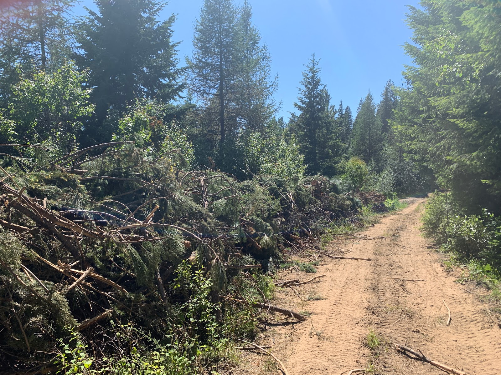
I realized that I was off route and I had to turn around. I would never do this route without GPS. There were sparkles in the road like broken glass, but I saw no litter here out in the wild. The sparkles were probably schist fragments. I rode back to the turn-off where the second campfire had been. I now found myself on a primitive road, overgrown with weeds, that hadn't been used in a long time. I double checked my GPS to make sure that I was on the right track. I came to a gate across the road that my paper map said to continue. As I was tilting my bike underneath the gate, I realized that I had lost one of the water bottles that I had purchased in Lolo. One of the numerous washboards had knocked it loose. Riding downhill I came to an area that was being logged. I could hear chainsaws in the distance and saw freshly cut branches stacked along the path. I came to where they were cutting down the trees. There was heavy machinery in the road, and I didn’t want to startle the workers. I was riding right behind a vehicle, and I shouted "hi" to the workers. One of the guys with a chainsaw replied, "Right on!".
I turned onto a wide gravel road and rode down in to the valley towards the river. I crossed Crooked Fork Creek and found myself on Crooked Fork Road headed back towards Highway 12. I passed White Sands National Forest Campground, and was now riding alongside the Lochsa River. This had definitely been the way to experience the south side of this pass! I left US Forest Service land, and found myself exiting through a ranch gate. I noticed cabins and other buildings. A female jogger ran by me, as I rode past the Clearwater National Forest Powell ranger station.
I returned to asphalt, and was thrilled by my off-road experience. It had been totally bronco-bucking amazing. I walked my bike up a steep path into Lochsa Lodge and saw four tents pitched behind the general store. I set up my tent and took a shower. I went to the lodge, where I sat out on the back porch and ordered a Cold Smoke Scotch Ale. I had the BBQ ribs with chicken enchilada soup, salad, and french fries. I worked on this report until the no see-um's drove me inside. When the lodge closed, I returned to my tent.


Comments
Post a Comment