Covid Cross Day #33 Circle, MT to Jordan, MT
Covid Cross Day #33
July 6, 2020
Circle, MT to Jordan, MT 68 Miles
Start 8:43 AM Finish 4:20 PM
Ride Time 6:24
Ascent 2095 Feet
Descent 1943 Feet
Tour Total 2805 Miles
I slept well last night on the cement slab underneath the picnic pavilion at the City Park in Circle. It didn't rain, but I was playing it safe. My Thermarest was so good that I could sleep comfortably anywhere. I woke up with the sun. I made use of the electrical outlet to recharge my devices. I finished yesterday‘s report on the picnic table this morning. I finally performed a micro adjustment on my saddle, which had been slightly out of whack since New Salem. It was already windy and the sun was bright.
I ran into Bill on the main strip. He was coming back from the grocery store. He joined me at the Lunchbox, where I ordered an egg and bacon burrito, a large mocha latte, and three bottles of orange juice. The breakfast burrito tasted like shoe leather. Bill was taking an off-day today. We both agreed that yesterday was brutal. He was having saddle sore issues. He didn’t have a Brooks saddle and his cycling shorts were worn and didn't have a puffy chamois. He mentioned that his saddle was angled up in the front. That spelled a recipe for soreness. Bill was a retired fire battalion chief. He was navigating using Google maps and pages ripped out of an atlas. His map pages didn’t show small roads, and Google maps wouldn’t work when he didn't have cell phone service.
I stopped at the post office before heading out of town. I was now on State Highway 200. There was no longer a Highway S suffix after Circle. Last year, I had headed north from Circle to Wolf Point to get on the Montana Hi-Line. This year I was continuing straight west on State Highway 200. I was no longer on the Northern Tier route. It would be new territory for me until Missoula. Today's destination, Jordan, was 67 miles away.
My wind app had forecast a mild breeze from the north. The reality was that it was from the south. There was a large weather system to the west. My weather app forecast thunderstorms at noon. I was in the Redwater River Valley which I only realized from my paper map. The river was to my south and was all twisted like a snake. There was a distant ridge on the other side of the river to the south. It was relatively flat and I was averaging 15 miles an hour.
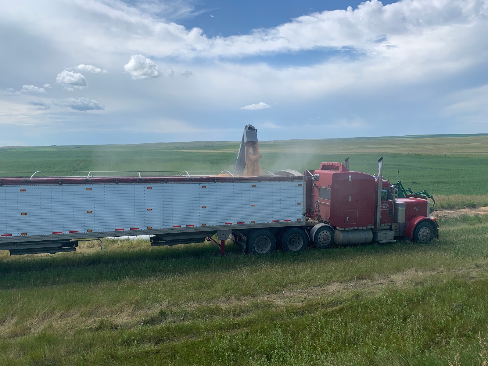
I could see the grain elevator at Brockway from several miles away. The town was a mile off route, and I wasn’t planning to stop. Jack had told me yesterday that there was a good restaurant there, which would be opening half an hour after I passed. The railroad track line that I had been following had ended at Circle. Bill and I both talked about all the empty cars we passed yesterday. He’d been measuring the lengths of trains with his odometer. The highway changed course outside of Brockway, and now had a due-west heading. I climbed up over a ridge and left the river valley. The ridge was longer and steeper than it had appeared from the distance. The shoulder was four inches wide with grass growing up through the middle, so I rode to the left of the white line. It was a tight squeeze when motorists passed.
As I rode over the top of the ridge and headed straight west, I realized that the large weather system was to the south west. I was relieved that we would be passing one another with no adventure stories. I realized that now, because I was no longer on the Northern Tier route and solely on the Lewis & Clark route, my chances of running into other cyclists had diminished. I shouldn’t have complained about the four inch shoulder because it was better than the two inch shoulder or the sections with no shoulder. I enjoyed the perfume scent from a nearby field of wildflowers.
The road headed straight west with rolling ups and downs. I saw a truck pulled over in the distance, a fuel tanker with an extra tank in tow. The driver was testing all of his tires with a large mallet. He asked me if the hills were giving me as much trouble as they were giving him. I replied that he was carrying a much heavier load. His route ran back-and-forth between Great Falls and Glendive. He said he’d see me on his way back. There was another system brewing in the west. There were lots of puffy clouds in the sky today. A sign read, 'Rough Narrow Road Next 20 Miles'. I came to the intersection of State Route 24, which led north up to Fort Peck Lake. An ACA alternate route split up to the lake, but I would be continuing due west. There was a rest area and I stopped.
I used the bathroom and drank from the water fountain. There was a large Montana map which I studied. I enjoyed interesting facts about the construction of the Fort Peck Dam, as well as information about dinosaurs. I got back on the road and entered Garfield County. There was a construction sign saying 'Loose Gravel Ahead' and 'Rough Road Area.' The speed limit for motorists was reduced to thirty-five miles an hour. There was definitely now a weather system to the west with dark purple clouds. I was halfway to my destination.
The wind was getting strong out of the south, and the clouds ahead kept getting darker. My default weather app forecast storms. Dark Sky predicted no precipitation. There were a lot of RV's, campers, and boat trailers out on the highway today. At one point I heard the crack of thunder. Several miles further down the road it seemed pretty clear that the severe weather system was going to pass me to the north. It was still gray ahead but I was pretty certain that I would escape the worst of it. I felt a few drops and then I looked down and saw my shadow. The weather here in Montana would change from one moment to the next. And then, all of a sudden the road widened, and I got a shoulder.
The rumble strips were full of water twelve miles east of Jordan, meaning that it had rained here earlier. I had a headwind at this point. The rumble strips ran right down the middle of the shoulder. Thank you Montana DOT. It began to sprinkle six miles out from Jordan. I was surrounded by buttes, bad-land formations, ridges, grass, sage brush, a barbwire fence to the left, and two strings of telephone lines to my right. There were no trees, cows, structures, nothing.
I loved the emptiness here and it was such a contrast to New York. It was like hitting the reset button. It was a cleansing and purge from overstimulation. The drizzle stopped three miles out from Jordan, and I could see buildings in the distance. At long last I spotted the 'Welcome to Jordan' sign. I passed the Garfield County Museum. I had heard there were a lot of dinosaur finds from around here. I stopped at Jakes Place Cafe, which was shocking and depressing. Inside the empty building were restrooms, seating, and vending machines. I kept riding towards the center of town.
There were two bars and I settled on Hell Creek Bar. A TURD 2020 sign was on the door. The first comment from the peanut gallery was, "We don’t allow bikers in here." I laughed. What a bunch of pussies. Liberals, conservatives - you're all a bunch of whining crybabies. All of you motherfuckers should throw your cars in the garbage and go for a long bike ride.
I ordered a pint of Überbrew White Noise and a double cheeseburger with fries. I got to talking with the bartender who asked me, "So, Are you a liberal?". "Yes", I replied. "People were trying to divide us for their own personal gain. We need each other you and I." My liberal artist friends desperately trying to advance their careers through political posturing are just as bad as TURD. Let's cool things down and stop the division. Urban realities are different from rural. Why fight each other? We're all being manipulated.


Comments
Post a Comment