Covid Cross Day #34 Jordan, MT to Winnett, MT
Covid Cross Day #34
July 7, 2020
Jordan, MT to Winnett, MT 77 Miles
Start 6:57 AM Finish 2:53 PM
Ride Time 6:34
Ascent 2710 Feet
Descent 2393 Feet
Tour Total 2881 Miles
I slept well in my tent in Jimmy Kariotis Park across the highway from the CENEX station in Jordan. The temperature went down to the mid-sixties last night and it was perfect sleeping weather. I didn't hear any traffic from nearby Highway 200. There was condensation under my fly this morning, which I thought was odd for 2500 feet elevation.
I used the park outhouse and filled my water bottles from the spigot. My next stop would be Summit Corral for breakfast. Riding up the hill my rear derailleur cable snapped. I repaired it out front of the restaurant before going in for breakfast. The spare cable was from Mike’s Bike & Hike in Richmond, KY. It took five minutes to fix.
I met a friendly rancher at Summit Corral who had a friend whom had moved to Brooklyn. I ordered eggs over-easy with bacon, toast, coffee, and orange juice. The rancher asked me about my trip, and how many miles per day I pedaled. There was a big storm coming, and there wasn't much between here and Willett, only a rest area at Mosby. I told him my North Dakota hailstorm story, and he said he'd seen sheep blinded by hail stones. I met a couple from Minnesota who were driving out west to see their daughter in Whitefish. There was another couple from eastern Montana near the North Dakota border. They had a cabin near Fort Peck Lake. They told me that the grasshoppers had been really bad this year, and we talked about Morman crickets.
My new gear cable was as smooth as silk, but I no longer had a spare. I rode back out into the barren plains. It was a little chilly and I had some wind. A black pick-up truck drove by me and gave me a friendly tap-tap while passing. I believe I’ve only had one aggressive honk so far this tour. I had a nice wide shoulder. It was four feet across with an additional gravel slant. The rumble strip was right up against the white line. I climbed up on top of a ridge and noticed a few cows to the left. A little ways down the road I noticed sheep out in the scrub grassland to the right. I pulled over to take a photo and then realized there were thousands of them along with herding dogs. The sheep were frightened and ran away from me, like a swarm. Further down the road I saw two herds of antelope out in the distance. There was a strong cross wind. I spotted a roadkill fox, and another road kill snake.
I was headed southwest and the wind was from the southeast. It definitely helped. I stopped to talk to some horses. There were a dozen or so, and they ran together in tandem. One of them seemed to be the leader and the others took their cue from him. They were afraid of me but curious. It was mostly overcast with thick clouds on the horizon. The sun was trying to come through. I was riding up and down over ridges. My profile map looked like a serrated knife. I was climbing up over another ridge and noticed something on top of a butte up ahead. It looked like a ginormous eagle, but I wasn't sure. The moment I approached, a huge bald eagle took off in flight. He followed me down the highway and circled twice to let me know he was watching me. I tried and failed to get a photo.
Three semi-trucks passed me hauling drill bits so large that only four could fit on a flatbed trailer. Fifteen miles west of Jordan I passed my first Montana white cross, a twin set. The rancher at breakfast this morning had said this was the scenic route compared to the Hi-Line. I passed a sign that said Great Falls 212 miles ahead. My route would be taking me off of Highway 200 around Lewiston, and would be 48 miles longer.
I passed a collection of beehives in a field, the first I’d seen since North Dakota. There were two cell phone towers thirty miles west of Jordan. Two distinct storm systems could be seen to the west, one to the north and another to the south, just like yesterday. I didn’t bother to put on sunscreen or chamois butter today. I was now far from level one, and I should have taken a birdbath in the campground last night.
I passed Edwards without even knowing it. I was confused when I rolled into Sand Springs. There was a store which doubled as a US post office. I purchased a red Gatorade along with salted peanuts. I signed the cyclist guestbook and saw many familiar names. The clerk said that not too many cyclists had been through this year, because of COVID. They hadn't seen a single case of the disease in Garfield county. In addition to a restroom there was also a shower room, but I didn’t feel that disgusting.
As I was headed out of town, a postal service driver pulled over and warned me about the coming storm. Lightning alerts were pinging her phone pretty bad. She said that I would get hit by the storm before I reached Mosby, eighteen miles to the west. A pack of antelope were running across the prairie on the west side of town. Just to the north of the highway I passed O’Day Butte, which was 3366 feet tall. My average elevation today was 3000 feet. A twin engine prop plane flew overhead.
On a long downhill coming off of a ridge I was pelted by what I believed were bugs. Most of the impact was on my calves. I couldn’t see what they were. Fortunately I didn’t have this issue on the uphill. I came up on a ridge, and all of a sudden there were trees. Evergreens were on the south side of the highway and dead barren tree skeletons on the right. There had obviously been a fire. I hadn’t seen this many trees in a long time.
I had a six mile downhill down into the Mussleshell River valley. There were even more groves of pine trees in the valley. Mosby was also known as Half Breed Crossing. There used to be a gas station and a post office, but now it was just a rest area. I pulled into the rest area to look at the historical signs and respond to some work emails. There was a sketchy couple in a motor vehicle with Wisconsin plates, so I got back on the road.
I crossed over the Mussleshell River into Petroleum County. The Mussleshell was a tributary of the Missouri. During the 1860's mining boom, Montana schemers tried to route steamship transport down the river here but the current was too unpredictable. I’d been seeing signs in this part of the state that say "Save the Cowboy. Stop the American Prairie Reserve." Riding back up out of the other side of the valley I was bothered by lots of small grasshoppers, mosquitoes, and deer flies. Before coming down into the valley, I had thought that I could see a cluster of mountains in the distance to the west, but wasn’t sure. Once I reached the prairie on the west side of the valley I could make them out more clearly. There were definitely land formations out to the west.
Fifteen miles out of Winnett I had very little to no shoulder. The bugs were driving me crazy and I wished the motorized traffic would slow down just a little bit when passing me. What was the rush? I finally got to the top of a ridge and had a down-hill and lost the bugs and deer flies. I was definitely now seeing mountains ahead, and wondered if I had noticed this range from the Hi-Line last summer.
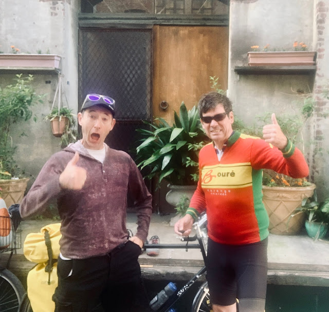
I met eastbound cyclist Greg from Boise Idaho, who was doing the Northern Tier from Anacortes to Bar Harbor. He was trying to make it to the rest area in Mosby before the storm hit. He had headwinds today. Everyone was talking about the big storm coming through. He said I was the third cyclist he'd met on his tour. Greg was blogging on Crazy Guy at: https://www.crazyguyonabike.com/doc/?o=1mr&doc_id=23047&v=8L He said there was a great bar & grill in Winnett and a place to camp near the swimming pool. I was ten miles from my destination. The wind was on my side today. I passed some sort of shooting range to the south.
All of my cycling buddies were checking in with me about the storm. Bill had made it to Jordan. Chris and Sidd were stuck in a ditch underneath a tarp. I flipped my map section four miles out of Winnett, and could now see that I would be riding up into the Judith mountains tomorrow. That was the range I had spotted today, and it looked like I would be climbing a 4700 foot pass tomorrow. I was admiring a fantastic butte to the south, and Winnett snuck up on me. I passed the welcome sign. I took a left on County Road 244 and rode into town. I could now see a giant W on the side of the large bluff that I had admired. I passed a small grain elevator, a gas & oil depot, a general store, a bar & grill, and a post office.
I spotted the sheriff and asked him about camping. He told me that the coming storm stretched from Billings to the Hi-Line. There were confirmed tornado touchdowns and hail. I called City Hall and got permission to camp in the City Park, and then went to the Winnett Bar and Grill. TURD 2020 signs were everywhere. I ordered a Street Fight Amber Ale from Angry Hank's Microbrewery. To eat I got a cheeseburger and fries. I tried the Salmon Fly Honey Rye by Madison River Brewing Company, and switched over.
A bunch of young bohemians from Tacoma were passing through in a car. They were concerned about the weather, and went across the street to the courthouse, which had a basement. Everybody's cell phone alerts were going off. A tornado had touched down ten miles out of town. The bartender exclaimed, "Some people call it tornado. We call it a breeze." It was super windy outside, and I went out to check on my bike. Everyone was excited and we were all glued to the window. The hailstones were the same size that I had been pelted with in North Dakota. At long last, the storm passed. I ordered a slice of marionberry pie, and finished this report.


Comments
Post a Comment